GPX Editor

Everything the app can do, explained step by step.

Track management

A GPX file can contain one or more tracks. The start screen lists every track it contains and gives you quick access to the tools you need to work with them.

  •   Open GPX file - loads all tracks from a GPX file. If a file is already open, the new tracks are simply added to it.
  •   Create new GPX file - starts an empty file. Use "Add GPX" to bring in content from another file afterwards.
  •   Share GPX file - opens the system share dialog to export the current file via email, AirDrop, Messages or any other installed app. The current state of all edited tracks is saved first.
  •   Sort tracks - orders the tracks so that they lie as close to each other as possible and form as complete a route as possible.
  •   Metadata info - view and edit general information about the file as a whole, such as name, description, author, creation time, keywords and links.
  •   Settings - customize display options and defaults used when creating or editing tracks. Changes are saved automatically and apply to every GPX file you open.

Selecting and merging tracks

Switch to selection mode to work on several tracks at once:

  •   Merge tracks - combines the selected tracks into a single new track. Afterwards you choose whether to delete the original tracks or keep them in the file.
  •   Move boundaries - when two tracks directly follow one another, shift the point where they meet so that one track becomes shorter and the other longer. Available only when exactly two tracks that are directly adjacent are selected.
  •   Delete tracks - removes the selected tracks from the GPX file.
  •   Export tracks - saves the selected tracks to a new GPX file.

Segment view and analysis

Opening a track shows various tools for analyzing it and dividing it into individual sections.

Speed profile - shows or hides the speed profile graph over the entire route, so you can spot fast and slow sections at a glance.

Climb profile - shows or hides the elevation chart together with every detected climb. Tap the button in the bottom-right corner of the chart to open a detailed list of all climbs and their profiles.

Edit segments - activates edit mode so you can move existing segment boundaries by dragging them on the elevation profile or on the map. The statistics of the affected segments update automatically.

Cut the track - splits the track into two segments at the currently selected track point. Before you confirm, the cut is shown as a dotted vertical line on the graph.
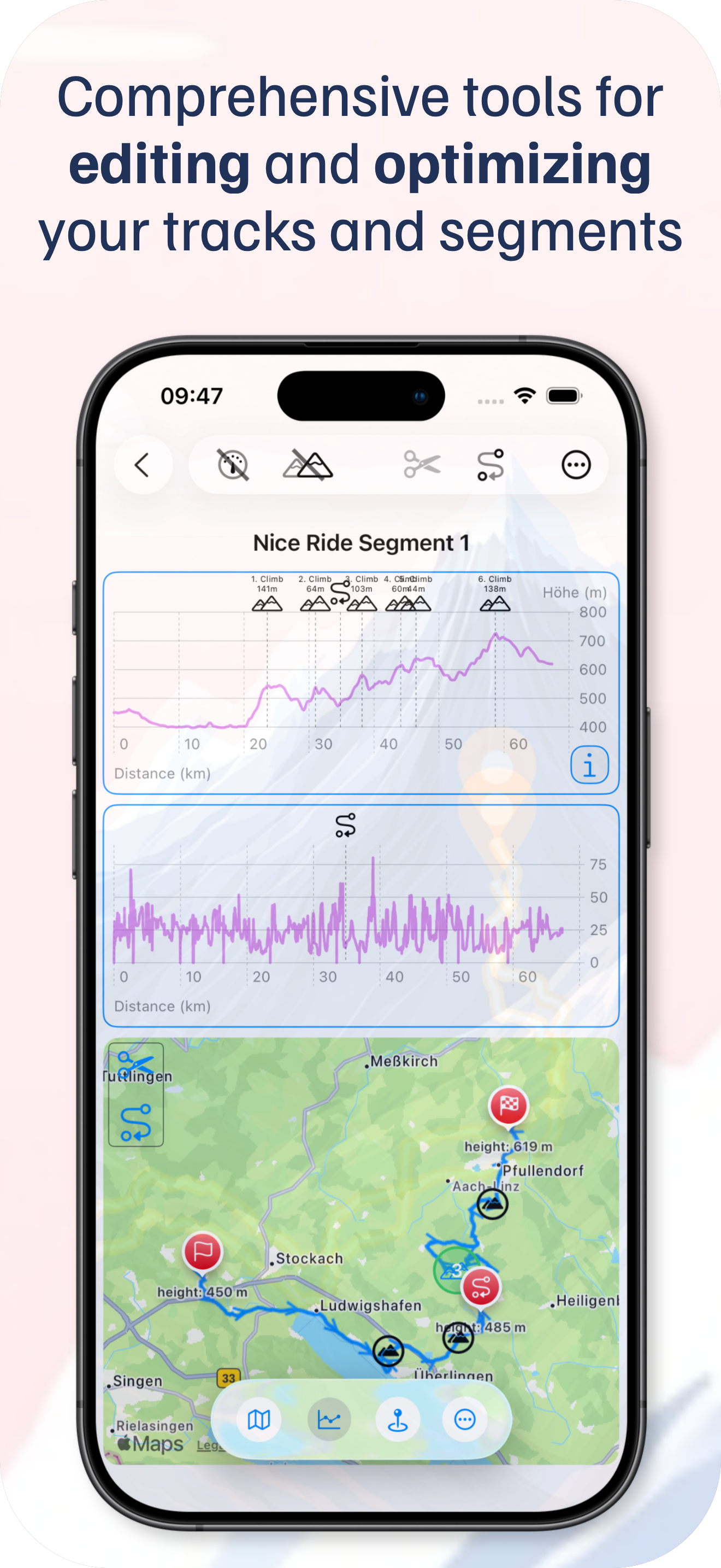
Segment view in GPX Editor

Editing segments

  •   Delete segment - removes the selected segment. Disabled if the track consists of only one segment.
  •   Segment info - shows all information about a segment and lets you move its boundaries. Use the left/right arrows or the slider to shift a boundary in 50-meter increments without creating a gap or overlap - the transition always stays seamless. This requires the track to consist of at least two segments.
  •   Save segment as - saves the selected segment either as a track in the current file or as a new GPX file containing the segment as its own track.

Managing track points

  •   Reduce the number of track points - intelligently thins out a track, from fixed distance or time intervals to an even distribution across the whole route or an optimized count based on the route's course. The app may suggest a reduction whenever you load a GPX file.
  •   Search for metadata - finds every track point whose metadata contains the search text.
  •   Change view - switches between the map view and the ascent view.
  •   Delete track point - permanently removes the currently selected track point. This cannot be undone.
  •   Filter ascending peak - shows only the track points that mark the end of an ascent.
  •   Filter metainfo - shows only the track points that have metadata attached.
  •   Trackpoint metadata - swipe a track point to the left to view and edit its metadata.

Editing track points

Track point editing lets you modify part of a track: insert new points, replace existing ones, or use routing to generate an optimized set of points for a section. Press the edit button repeatedly to cycle through the modes:

  •   Start track point editing
  •   New route for a limited area
  •   Replace track point
  •   Insert track point

  Undo track adjustment - reverts every change you made to the track during the current session.

Fine-tuning the settings

The settings let you tailor how tracks are analyzed and processed:

  • Ascent threshold - the percentage gradient at which a difference in altitude counts as an "ascent". A low value picks up even small gradients, a high value only recognizes steep climbs. Useful for elevation profiles, total ascent and training evaluations.
  • Min. ascent - the minimum elevation gain, in meters, that a continuous climb must reach before it is added to the total accumulated ascent. Positive elevation changes are collected continuously; if the set minimum isn't reached before a descent begins, those meters are not counted, and a new accumulation starts once the climb resumes.
  • Maximum track spacing - the largest distance between two tracks that the app still treats as adjacent. Only within this distance can the boundary between them be moved.
  • Track recalculation range - how many neighboring points are included when a route is recalculated. Lower values are faster and change less; higher values produce smoother, more realistic paths. 2-5 works well for most tracks - keep in mind this recalculates a track, not a route, and very large numbers of points can make it slow.
  • Optimal number of track points - the maximum number of points a track is reduced to when a GPX file is loaded. More track points can slow down processing, so lowering this value improves performance.